file:BritishEmpire1919.png
Ii preview ke size: 800 × 409 pixels Duusra resolutions: 320 × 163 pixels | 640 × 327 pixels | 1,425 × 728 pixels.
Original file (1,425 × 728 pixel, file ke size: 52 KB, MIME type: image/png)

|
This historical map image could be re-created using vector graphics as an SVG file. This has several advantages; see Commons:Media for cleanup for more information. If an SVG form of this image is available, please upload it and afterwards replace this template with
{{vector version available|new image name}}.
It is recommended to name the SVG file “BritishEmpire1919.svg”—then the template Vector version available (or Vva) does not need the new image name parameter. |
Sanchhipt me
| Baare me |
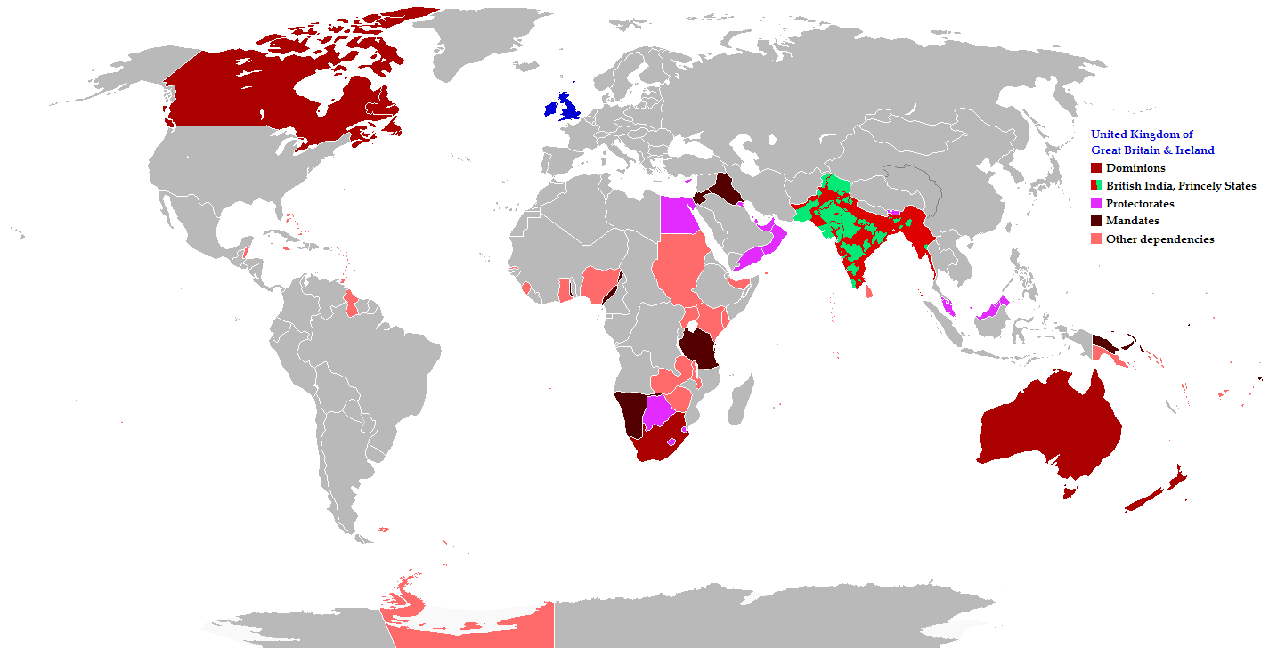
English: Map of the British Empire in 1919 showing all the territories, including the dominions, colonies, protectorates and mandates, ruled or administered by the United Kingdom and its successor states during that year.
Français : Carte de l'Empire britannique en 1919 illustrant tous les territoires, tels que les dominions, colonies, protectorats et mandats, gouvernés ou administrés par le Royaume-Uni ou ses États successeurs cette année-là.
Español: Un mapa de todas las afirmaciones oficiales territorial del Imperio Británico que se celebró en 1919 que identifica qué tipo de celebración estaba presente en todas las posesiones durante ese año.
Deutsch: Eine Karte aller offiziellen territorialen Ansprüche des Britischen Empire, die es im Jahre 1919 hatte, nach Art der Besitzungen in diesem Jahr.
فارسی: نقشه بیمورد از همه ادعاهای ارضی رسمی امپراطوری بریتانیا که در سال 1919 که برای شناسایی نوع برگزاری در حال حاضر تمام اموال در آن سال برگزار شد.
Português: Mapa de todos os territórios reclamados pelo Império Britânico, em 1919, que identifica o tipo de presença britânica no local naquele ano. |
| Taarik | |
| Source |
The following: |
| Likhe waala | Maps & Lucy |
| Adhikaar (Ii file ke fir se kaam me laawa jaae hai) |
Released into the public domain (by the author). |
| Other versions | العربيَّة |
Legend
Deutsch (de):
Licence ke baare me
This file is licensed under the Creative Commons Attribution-Share Alike 2.5 Generic license.
- You are free:
- share kare ke khaatir – to copy, distribute and transmit the work
- to remix – to adapt the work
- II condition ke niiche:
- attribution – Aap ke thiik credit de ke chaahi, licence pe jorr de ke chaahi, aur badlao ke dekhae ke chaahi. Aap iske koi reasonable manner me kare saktaa hai lekin aise nai ki lage ki licensor aap ke, nai to aap ke kaam ke endorse kre hai
- share alike – Agar aap milaata hai, badaltaa hai, nai to material pe jorrtaa hai, tab aap ke aapan yogdaan ke same or compatible license ke niche baate kare kae chaaahi.
File ke itihaas
File ke dekhe khatir, jaise uu time dekhe me lagat rahaa, date/time pe click karo.
| Din/Time | Chhota chapa | Lambai aur chaurai | Sadasya | Tiprrin | |
|---|---|---|---|---|---|
| abhi waala | 08:26, 31 Actobar 2021 | | 1,425 × 728 (52 KB) | Randomastwritter | jubaland |
| 20:43, 17 Navambar 2014 |  | 1,425 × 728 (61 KB) | GrenaderGD44 | Убраны артефакты с карты в районе Антарктиды | |
| 01:40, 17 Navambar 2014 |  | 1,425 × 728 (65 KB) | GrenaderGD44 | Бутан - протекторат с 1910 года | |
| 18:36, 9 Maach 2014 |  | 1,425 × 625 (39 KB) | Htonl | Bechuanaland, Basutoland and Swaziland were protectorates | |
| 20:02, 18 Juun 2011 |  | 1,425 × 625 (55 KB) | Maps & Lucy | The British Empire, Mongolia and the Soviet Union all recognized Tibet as an independent state and the British Empire via British India were heavily involved in Tibet's independence. | |
| 19:05, 7 Mai 2011 |  | 1,425 × 625 (58 KB) | Quigley | Correct China's borders closer to what was internationally recognized at the time | |
| 23:55, 15 Disambar 2010 |  | 1,425 × 625 (55 KB) | Maps & Lucy | Added protectorates and Princely States | |
| 22:47, 10 Disambar 2010 |  | 1,425 × 625 (53 KB) | Maps & Lucy | Papua was a colony not a dominion, Gold Coast did not include British Togoland and British Togoland was a mandate. | |
| 18:20, 7 Navambar 2010 |  | 1,425 × 625 (59 KB) | Spesh531 | fix mistake in botswana | |
| 18:19, 7 Navambar 2010 |  | 1,425 × 625 (56 KB) | Spesh531 | really a way to revert. use this version |
File ke kaise kaam me lawa gais hae
Niche ke panna kaam me laae hai ii file ke:
Global file usage
Ii aur duusra wiki ii file ke use kare hai:
- af.wikipedia.org pe upyog
- ar.wikipedia.org pe upyog
- azb.wikipedia.org pe upyog
- az.wikipedia.org pe upyog
- ba.wikipedia.org pe upyog
- be-tarask.wikipedia.org pe upyog
- be.wikipedia.org pe upyog
- bg.wikipedia.org pe upyog
- bs.wikipedia.org pe upyog
- bxr.wikipedia.org pe upyog
- cdo.wikipedia.org pe upyog
- de.wikipedia.org pe upyog
- el.wikipedia.org pe upyog
- en.wikipedia.org pe upyog
- eo.wikipedia.org pe upyog
- fiu-vro.wikipedia.org pe upyog
- fi.wikipedia.org pe upyog
- fr.wikipedia.org pe upyog
- he.wikipedia.org pe upyog
- hr.wikipedia.org pe upyog
- hy.wikipedia.org pe upyog
- ia.wikipedia.org pe upyog
- id.wikipedia.org pe upyog
- is.wikipedia.org pe upyog
- ja.wikipedia.org pe upyog
- kk.wikipedia.org pe upyog
- krc.wikipedia.org pe upyog
- lez.wikipedia.org pe upyog
- lo.wikipedia.org pe upyog
- lv.wikipedia.org pe upyog
- ms.wikipedia.org pe upyog
- mwl.wikipedia.org pe upyog
- my.wikipedia.org pe upyog
- nl.wikipedia.org pe upyog
- nn.wikipedia.org pe upyog
- pnb.wikipedia.org pe upyog
- qu.wikipedia.org pe upyog
- ru.wikipedia.org pe upyog
Ii file ke more global usage kedekho.