file:Map-Lusophone World-en.png

Ii preview ke size: 800 × 370 pixels Duusra resolutions: 320 × 148 pixels | 640 × 296 pixels | 1,357 × 628 pixels.
Original file (1,357 × 628 pixel, file ke size: 37 KB, MIME type: image/png)
Sanchhipt me
| Baare me |
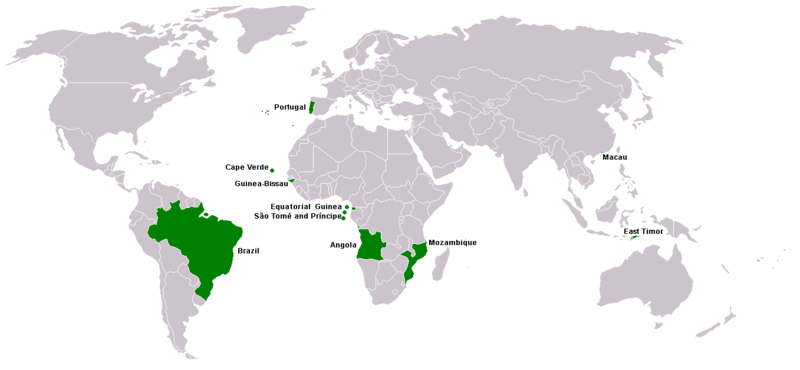
Map of Lusophone world. Map made from Image:BlankMap-World.png. The blank map was made by User:Vardion and adapted by User:E Pluribus Anthony for Wikipedia. |
||||
| Taarik | |||||
| Source | Aapan kaam | ||||
| Likhe waala | This version was made by User:Yug with country names by User:Sting. Fixed by User:The Ogre | ||||
| Adhikaar (Ii file ke fir se kaam me laawa jaae hai) |
|
||||
| Other versions |
|


File ke itihaas
File ke dekhe khatir, jaise uu time dekhe me lagat rahaa, date/time pe click karo.
| Din/Time | Chhota chapa | Lambai aur chaurai | Sadasya | Tiprrin | |
|---|---|---|---|---|---|
| abhi waala | 21:35, 7 Maach 2018 | | 1,357 × 628 (37 KB) | Maphobbyist | South Sudan border |
| 15:13, 21 Aprel 2016 |  | 1,357 × 628 (14 KB) | Avayak | optimized losslessly | |
| 23:09, 22 Farwari 2008 |  | 1,357 × 628 (47 KB) | The Ogre | New version, taken from the English wikipedia, where en:User:Domaleixo had done a new version of this map adding Equatorial Guinea, that also has Portuguese as official language. The license is "I, the copyright holder of this work, hereby release it | |
| 03:20, 4 Juun 2007 |  | 1,357 × 628 (47 KB) | Hoshie | added Cabinda (Angola) and Montenegro. Same license. Put Cabinda in green as it is a part of Angola. | |
| 16:06, 4 Mai 2007 |  | 1,357 × 628 (19 KB) | Tene~commonswiki | Optimised (0) | |
| 14:00, 4 Mai 2007 |  | 1,357 × 628 (47 KB) | EugeneZelenko | Corrected version from Image:Map-Lusophone World-eng.png by User:The Ogre. Same license. | |
| 18:50, 23 Janwari 2006 |  | 1,357 × 628 (38 KB) | Sting | Map of Lusophone world. Map made from Image:BlankMap-World.png The blank map was made by User:Vardion and adapted by User:E Pluribus Anthony for Wikipedia. This version was made by User:Yug with country names by [[Us |
File ke kaise kaam me lawa gais hae
Ii file ke koi panna kaam me nai laae hai.
Global file usage
Ii aur duusra wiki ii file ke use kare hai:
- da.wikipedia.org pe upyog
- de.wikipedia.org pe upyog
- en.wikipedia.org pe upyog
- fr.wikipedia.org pe upyog
- nl.wikipedia.org pe upyog
- nn.wikipedia.org pe upyog
- no.wikipedia.org pe upyog
- pt.wikinews.org pe upyog
- sv.wikipedia.org pe upyog
- zh.wikipedia.org pe upyog