file:Map Canada political-geo.png

Ii preview ke size: 680 × 599 pixels Duusra resolutions: 272 × 240 pixels | 545 × 480 pixels | 872 × 768 pixels | 1,162 × 1,024 pixels | 1,280 × 1,128 pixels.
Original file (1,280 × 1,128 pixel, file ke size: 492 KB, MIME type: image/png)
Sanchhipt me
| Baare me |
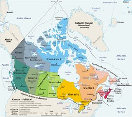
Map: Canada – geopolitical Drawn and adapted by E Pluribus Anthony from Atlas of Canada Edited by en:User:Heqs/en:User:Cogito ergo sumo to show disputed nature of Canada's marine international boundary claims; see en:Canada-United_States_border#Remaining_boundary_disputes; further edited by Bosonic dressing to reflect agreed maritime boundary between Canada and Greenland/Denmark: see http://www.dur.ac.uk/resources/ibru/arctic.pdf |
| Taarik | 11 Maach 2006 (original upload date) |
| Source | Originally from en.wikipedia; description page is/was here. |
| Likhe waala |
Original uploader was E Pluribus Anthony at en.wikipedia Later versions were uploaded by AThing, Heqs, Cogito ergo sumo at en.wikipedia. |
| Adhikaar (Ii file ke fir se kaam me laawa jaae hai) |
Released into the public domain (by the author). |
| Other versions | Derivative works of this file: Map Canada political-geo-be-x-old.png |
Licence ke baare me
| |
This work has been released into the public domain by its author, E Pluribus Anthony, at the English Wikipedia project. This applies worldwide. In case this is not legally possible: |
File ke itihaas
File ke dekhe khatir, jaise uu time dekhe me lagat rahaa, date/time pe click karo.
| Din/Time | Chhota chapa | Lambai aur chaurai | Sadasya | Tiprrin | |
|---|---|---|---|---|---|
| abhi waala | 07:37, 8 Navambar 2008 | | 1,280 × 1,128 (492 KB) | Bosonic dressing | {{Information |Description=Map of Canada, revised to reflect agreed border with Greenland/Denmark, per http://www.dur.ac.uk/resources/ibru/arctic.pdf |Source= |Date=8 November 2008 |Author=E Pluribus Anthony, et al |Permission= |other_versions= }} |
| 07:33, 8 Navambar 2008 |  | 1,280 × 1,297 (529 KB) | Bosonic dressing | {{Information |Description=Map of Canada, revised to reflect agreed border with Greenland/Denamrk, per http://www.dur.ac.uk/resources/ibru/arctic.pdf |Source= |Date=8 November 2008 |Author=E Pluribus Anthony, et al |Permission= |other_versions= }} | |
| 19:54, 15 Juun 2007 |  | 1,280 × 1,128 (496 KB) | PMG | {{Information |Description=Map: en:Canada – geopolitical Drawn and adapted by E Pluribus Anthony from [http://atlas.gc.ca/site/english/maps/reference/national/can_political_e Atlas of Canada] Edited by [[:en:User:H |
File ke kaise kaam me lawa gais hae
Niche ke panna kaam me laae hai ii file ke:
Global file usage
Ii aur duusra wiki ii file ke use kare hai:
- ace.wikipedia.org pe upyog
- ar.wikipedia.org pe upyog
- cu.wikipedia.org pe upyog
- cy.wikipedia.org pe upyog
- da.wikipedia.org pe upyog
- de.wikipedia.org pe upyog
- de.wikivoyage.org pe upyog
- en.wikipedia.org pe upyog
- Talk:Ottawa
- Talk:Montreal
- Talk:Toronto
- Talk:Whatì
- Talk:Brampton
- Talk:Emerald Park, Saskatchewan
- Wikipedia talk:WikiProject Toronto
- Talk:St. John's, Newfoundland and Labrador
- Talk:North Bay, Ontario
- Talk:List of communities in Quebec
- Talk:Saguenay, Quebec
- Talk:List of cities in Canada
- Talk:Carleton Place
- Talk:London, Ontario
- Talk:St. Catharines
- Talk:Etobicoke
- Talk:Inuvik
- Talk:Tulita
- Talk:Surrey, British Columbia
- Talk:Montreal, Quebec
- Talk:100 Mile House
- Talk:Timmins
- Talk:Mississauga/Archive 2
- Talk:King, Ontario
- Talk:Medicine Hat
- Talk:Bramalea, Ontario
- Talk:Elliot Lake
- Index of Canada-related articles
- Talk:List of unincorporated communities in Ontario
- Talk:Vancouver
- Talk:Coquitlam
- Talk:Regent Park
- Talk:The Peanut
- Talk:List of the largest municipalities in Canada by population
- Talk:Thornhill, Ontario
- Talk:Kitchener, Ontario
Ii file ke more global usage kedekho.