file:Namibia map.png
Aur achchha resolution nai hai.
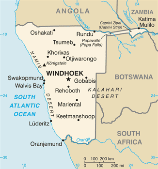
Namibia_map.png (326 × 349 pixel, file ke size: 19 KB, MIME type: image/png)
CIA map of Namibia
- See also the 2004 version.
.png)
This image is in the public domain because it contains materials that originally came from the United States Central Intelligence Agency's World Factbook.
|
 |
derivative works
Derivative works of this file: Namibia map-sv.png
File ke itihaas
File ke dekhe khatir, jaise uu time dekhe me lagat rahaa, date/time pe click karo.
| Din/Time | Chhota chapa | Lambai aur chaurai | Sadasya | Tiprrin | |
|---|---|---|---|---|---|
| abhi waala | 10:17, 17 Janwari 2022 | | 326 × 349 (19 KB) | Lojwe | Cropped 1 % horizontally, 1 % vertically using CropTool with precise mode. |
| 07:59, 21 Julai 2007 |  | 328 × 353 (20 KB) | Hoshie | Updated map of Namibia from the CIA World Factbook, 14 June 07 rev. Src: https://www.cia.gov/library/publications/the-world-factbook/maps/wa-map.gif | |
| 20:51, 4 Maach 2005 |  | 330 × 355 (9 KB) | Alfio | CIA map of Namibia |
File ke kaise kaam me lawa gais hae
Niche ke panna kaam me laae hai ii file ke:
Global file usage
Ii aur duusra wiki ii file ke use kare hai:
- af.wikipedia.org pe upyog
- ar.wikipedia.org pe upyog
- bg.wikipedia.org pe upyog
- ca.wikipedia.org pe upyog
- da.wikipedia.org pe upyog
- de.wikipedia.org pe upyog
- dsb.wikipedia.org pe upyog
- en.wikipedia.org pe upyog
- fi.wikipedia.org pe upyog
- fr.wikipedia.org pe upyog
- hr.wikipedia.org pe upyog
- hu.wikipedia.org pe upyog
- hu.wiktionary.org pe upyog
- incubator.wikimedia.org pe upyog
- it.wikipedia.org pe upyog
- ja.wikipedia.org pe upyog
- ka.wikipedia.org pe upyog
- kg.wikipedia.org pe upyog
- kn.wikipedia.org pe upyog
Ii file ke more global usage kedekho.