file:Tajikistan Map TI-map.gif
Aur achchha resolution nai hai.
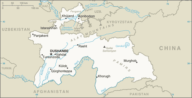
Tajikistan_Map_TI-map.gif (636 × 325 pixel, file ke size: 29 KB, MIME type: image/gif)
Sanchhipt me
| Baare me |
English: Tajikistan Map (This version of the map includes significant changes from the previous version of the map including changes to the China-Tajikistan border.) |
| Taarik | 2010s |
| Source | [1] |
| Likhe waala | CIA Factbook |
| Other versions |
|

![[1]](https://www.cia.gov/library/publications/the-world-factbook/attachments/maps/TI-map.gif)
Licence ke baare me
This work is in the public domain in the United States because it is a work prepared by an officer or employee of the United States Government as part of that person’s official duties under the terms of Title 17, Chapter 1, Section 105 of the US Code.
Note: This only applies to original works of the Federal Government and not to the work of any individual U.S. state, territory, commonwealth, county, municipality, or any other subdivision. This template also does not apply to postage stamp designs published by the United States Postal Service since 1978. (See § 313.6(C)(1) of Compendium of U.S. Copyright Office Practices). It also does not apply to certain US coins; see The US Mint Terms of Use.
|
 | |
| This file has been identified as being free of known restrictions under copyright law, including all related and neighboring rights. | ||
File ke itihaas
File ke dekhe khatir, jaise uu time dekhe me lagat rahaa, date/time pe click karo.
| Din/Time | Chhota chapa | Lambai aur chaurai | Sadasya | Tiprrin | |
|---|---|---|---|---|---|
| abhi waala | 00:49, 21 Janwari 2020 | | 636 × 325 (29 KB) | Geographyinitiative | User created page with UploadWizard |
File ke kaise kaam me lawa gais hae
Niche ke panna kaam me laae hai ii file ke:
Global file usage
Ii aur duusra wiki ii file ke use kare hai:
- ar.wikipedia.org pe upyog
- ast.wikipedia.org pe upyog
- bg.wiktionary.org pe upyog
- bn.wikipedia.org pe upyog
- ca.wikipedia.org pe upyog
- cs.wikipedia.org pe upyog
- dsb.wikipedia.org pe upyog
- el.wikipedia.org pe upyog
- en.wikipedia.org pe upyog
- en.wiktionary.org pe upyog
- eo.wikinews.org pe upyog
- es.wikipedia.org pe upyog
- eu.wikipedia.org pe upyog
- fa.wikipedia.org pe upyog
- fr.wikipedia.org pe upyog
- gd.wikipedia.org pe upyog
- gl.wikipedia.org pe upyog
- ha.wikipedia.org pe upyog
- hr.wikipedia.org pe upyog
- id.wikipedia.org pe upyog
- is.wikipedia.org pe upyog
- it.wikipedia.org pe upyog
Ii file ke more global usage kedekho.