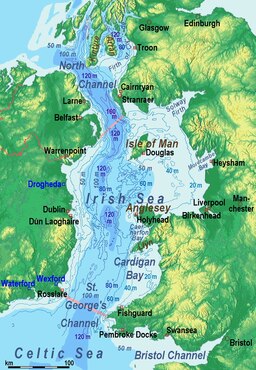
Irish Samundar
Ireland aur Great Britain ke biich ke samundar
(Irish Sea se bheja gais)
Irish Samundar[1], ek 46,007 km2 (17,763 sq mi) samundar hae jon Ireland aur Great Britain ke biich me hae. Ii St George's Channel se south me jurre hae, aur north me North Channel se jurre hae.
- ↑ "Muir Éireann". téarma.ie – Dictionary of Irish Terms. Foras na Gaeilge and Dublin City University. Archived from the original on 10 May 2017. Retrieved 18 November 2016.
| Irish Sea | |
|---|---|
 Satellite image | |
 Limits and ports: ◘ ferry port / Template:Blue freight only | |
| Location | Britain and Ireland |
| Coordinates | 53°30′N 5°00′W / 53.5°N 5.0°WCoordinates: 53°30′N 5°00′W / 53.5°N 5.0°W |
| Type | Sea |
| River sources | Rivers that flow into the Irish Sea |
| Ocean/sea sources | Celtic Sea |
| Basin countries | United Kingdom; Republic of Ireland; Isle of Man |
| Max. width | 200 km (120 mi) |
| Surface area | 46,007 km2 (17,763 sq mi) |
| Average depth | 80–275 m (262–902 ft) |
| Water volume | 2,800 km3 (2.3×10⁹ acre⋅ft) |
| Islands | Anglesey and Holy Island, Isle of Man and Calf of Man, Bardsey Island, Walney, Lambay, Ireland's Eye |
| Settlements | (see below) |