file:2009-09-29 Samoa Island Region earthquake location.jpg
Aur achchha resolution nai hai.
2009-09-29_Samoa_Island_Region_earthquake_location.jpg (420 × 468 pixel, file ke size: 57 KB, MIME type: image/jpeg)


Sanchhipt me
| Baare me |
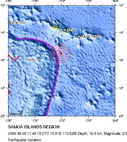
English: Earthquake location map. Major Tectonic Boundaries: Subduction Zones -purple, Ridges -red and Transform Faults -green
Deutsch: Erdbebenlagekarte. |
| Taarik | |
| Source | http://neic.usgs.gov/neis/eq_depot/2009/eq_090929_mdbi/neic_mdbi_l.html |
| Likhe waala | United States Geological Survey |
Licence ke baare me
This image is in the public domain in the United States because it only contains materials that originally came from the United States Geological Survey, an agency of the United States Department of the Interior. For more information, see the official USGS copyright policy.
|
File ke itihaas
File ke dekhe khatir, jaise uu time dekhe me lagat rahaa, date/time pe click karo.
| Din/Time | Chhota chapa | Lambai aur chaurai | Sadasya | Tiprrin | |
|---|---|---|---|---|---|
| abhi waala | 15:05, 1 Actobar 2009 | | 420 × 468 (57 KB) | Avenue | Updated version from USGS website: http://neic.usgs.gov/neis/eq_depot/2009/eq_090929_mdbi/neic_mdbi.jpg Created by USGS, so public domain. |
| 20:52, 29 Saptambar 2009 |  | 420 × 468 (57 KB) | Matthiasb | {{Information |Description={{en|1=Earthquake location map. Major Tectonic Boundaries: Subduction Zones -purple, Ridges -red and Transform Faults -green}} {{de|1=Erdbebenlagekarte. }} |Source=http://neic.usgs.gov/neis/eq_depot/2009/eq_090929_mdbi/neic_mdbi |
File ke kaise kaam me lawa gais hae
Niche ke panna kaam me laae hai ii file ke:
Global file usage
Ii aur duusra wiki ii file ke use kare hai:
- de.wikipedia.org pe upyog
- de.wikinews.org pe upyog
- en.wikinews.org pe upyog
- es.wikipedia.org pe upyog
- es.wikinews.org pe upyog
- eu.wikipedia.org pe upyog
- fi.wikipedia.org pe upyog
- fr.wikipedia.org pe upyog
- he.wikipedia.org pe upyog
- it.wikipedia.org pe upyog
- ja.wikipedia.org pe upyog
- ms.wikipedia.org pe upyog
- nl.wikipedia.org pe upyog
- no.wikipedia.org pe upyog
- pl.wikipedia.org pe upyog
- pl.wikinews.org pe upyog
- pt.wikipedia.org pe upyog
- pt.wikinews.org pe upyog
- ro.wikipedia.org pe upyog
- th.wikipedia.org pe upyog
- www.wikidata.org pe upyog
- zh.wikipedia.org pe upyog