file:India Madhya Pradesh location map.svg

Size of this PNG preview of this SVG file: 800 × 563 pixels. Duusra resolutions: 320 × 225 pixels | 640 × 450 pixels | 1,024 × 720 pixels | 1,280 × 900 pixels | 2,560 × 1,800 pixels | 1,041 × 732 pixels.
Original file (SVG file, naam kare ke khatir 1,041 × 732 pixels, file size: 180 KB)
Sanchhipt me
| Baare me |
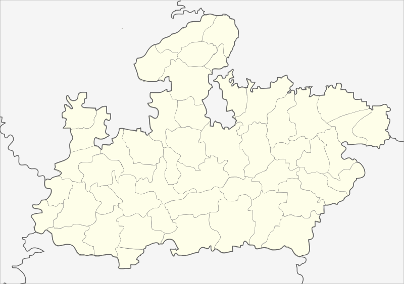
English: Locator map of Madhya Pradesh.
Geographical limits of the map:
Français : Carte de localisation du Madhya Pradesh, Inde. |
| Taarik | (UTC) |
| Source | India_Madhya_Pradesh_locator_map.svg |
| Likhe waala |
India_Madhya_Pradesh_locator_map.svg: user:Planemad
|
| Other versions |
|


| This is a retouched picture, which means that it has been digitally altered from its original version. Modifications: Cropped map of madhya pradesh. The original can be viewed here: India Madhya Pradesh locator map.svg:
|
Licence ke baare me
ii file ke Creative Commons Attribution-Share Alike 3.0 Unported license ke niche licence karaa gais hai.
- You are free:
- share kare ke khaatir – to copy, distribute and transmit the work
- to remix – to adapt the work
- II condition ke niiche:
- attribution – Aap ke thiik credit de ke chaahi, licence pe jorr de ke chaahi, aur badlao ke dekhae ke chaahi. Aap iske koi reasonable manner me kare saktaa hai lekin aise nai ki lage ki licensor aap ke, nai to aap ke kaam ke endorse kre hai
- share alike – Agar aap milaata hai, badaltaa hai, nai to material pe jorrtaa hai, tab aap ke aapan yogdaan ke same or compatible license ke niche baate kare kae chaaahi.
Original upload log
This image is a derivative work of the following images:
- File:India_Madhya_Pradesh_locator_map.svg licensed with Cc-by-sa-3.0
- 2006-08-06T17:38:20Z Planemad 1639x1852 (768594 Bytes) {{WikiProject_India_Maps |Title=Madhya Pradesh locator map |Description=Locator map of the state of Madhya Pradesh, [[w:India|India]] with district boundaries. |Source=. |Date=August 6 2006 |Author=[[w:user:Nichalp]][[w:user
Uploaded with derivativeFX
| Annotations | This image is annotated: View the annotations at Commons |
File ke itihaas
File ke dekhe khatir, jaise uu time dekhe me lagat rahaa, date/time pe click karo.
| Din/Time | Chhota chapa | Lambai aur chaurai | Sadasya | Tiprrin | |
|---|---|---|---|---|---|
| abhi waala | 22:26, 25 Farwari 2013 | | 1,041 × 732 (180 KB) | Milenioscuro | updated new districts, colors according german map workshop and the other India location maps |
| 12:19, 25 Navambar 2010 |  | 610 × 440 (146 KB) | Nayvik | Changed background color | |
| 12:13, 25 Navambar 2010 |  | 610 × 440 (146 KB) | Nayvik | {{Information |Description=Locator map of Madhya Pradesh.<br> Geographical limits of the map: * 28.0°N * 20.0°N * 84.0°E * 72.0°E |Source=*File:India_Madhya_Pradesh_locator_map.svg |Date=2010-11-25 12:11 (UTC) |Author=*[[:Fi |
File ke kaise kaam me lawa gais hae
Niche ke panna kaam me laae hai ii file ke:
Global file usage
Ii aur duusra wiki ii file ke use kare hai:
- de.wikipedia.org pe upyog
- de.wikivoyage.org pe upyog
- en.wikipedia.org pe upyog
- eo.wikipedia.org pe upyog
- fa.wikipedia.org pe upyog
Ii file ke more global usage kedekho.